The Restless Earth :
A Geologic Primer
A Geologic Primer
This article, together with its images, is reproduced from the website of the Burke Museum of Natural History and Culture, University of Washington, Seattle USA, so its emphasis is on the US Pacific Northwest region. However, most of its content relates to the Earth as a whole, and the article is extremely interesting - and very relevant in these times. http://www.washington.edu/burkemuseum/geo_history_wa/The%20Restless%20Earth%20v.2.0.htm
|
|
Geologic processes that operate on a global scale have profoundly affected the Pacific Northwest. By understanding just a few of these processes, you’ll be equipped to tackle Washington’s geologic history.
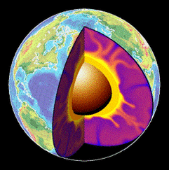
We place special emphasis on the basic processes of plate tectonics responsible for the evolution of Washington and the Pacific Northwest. Finally, we introduce the geologic time scale – a chronology of Earth and life history. Internal Structure of the Earth In composition, the Earth is made of three nested spheres. At the center of the Earth, a body of intensely hot iron and nickel forms the core. A less dense and much larger middle sphere is made of materials rich in iron, magnesium and calcium and comprises the mantle. The outermost layer is a thin veneer of lighter rocks and is called the crust. The crust beneath the oceans is composed of heavy, dark volcanic rocks such as basalt. Continental crust is composed mostly of lighter rocks rich in silica, such as granite. The Earth’s interior also has distinct physical layers without regard to composition. The outer layer is comprised of a rigid sphere called the lithosphere (“rocky sphere”). The lithosphere includes the upper, solid part of the mantle and all of the crust. The lithosphere is floating above a zone known as the asthenosphere (“weak sphere”). The asthenosphere behaves as a hot, ductile plastic. 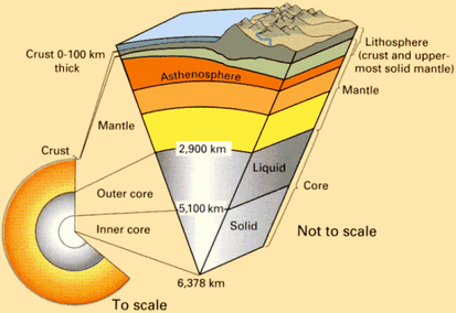
Internal structure of the Earth showing both compositional (core, mantle and crust) and physical layers (lithosphere and asthenosphere). (Image: USGS) To fully understand how the Earth changes, it is important to appreciate the basic distinction between crust and lithosphere.
The crust (both continental and oceanic) is the thin layer of distinctive chemical composition overlying the mantle. Very different processes form oceanic crust and continental crust. Oceanic crust is much thinner (typically 4 – 5 miles thick) and heavier than continental crust, which can range from 21 to nearly 30 miles thick. The lithosphere, in contrast, is the rigid outer layer of the Earth. It differs from the underlying asthenosphere by its physical and mechanical properties rather than its chemical composition. The lithosphere responds essentially as a rigid shell whereas the asthenosphere behaves as a very thick fluid. The diagram above illustrates both the chemical and physical layers within the Earth. Earth on a Slow Boil: Transferring Heat by Convection As you go deeper into our planet, the conditions of pressure and temperature steadily increase. The rocks become hotter and denser the deeper you go. The weight of all the overlying rocks causes the increase in pressure. The decay of heavy radioactive elements like uranium deep in the core produces the increase in heat. Nature is always uncomfortable with any unequal distribution of heat. It constantly works to equalize any temperature difference in the most efficient way possible. The Earth has a basic obligation to the laws of physics to transfer its internal heat into the cold universe that surrounds us. Because the interior of the earth is hot and under great pressure, it transfers much of its internal heat by a phenomenon called “convection.” Convection is the process by which hot materials rise, move laterally, cool, and then descend, in a cycle. You can see convection operating in a pan of boiling water. When water reaches a rolling boil, hot water rises in the center, cools as it spreads across the surface, then descends along the outside of the pan to complete the cycle. These cycles are convection cells. Within the Earth, irregular convection cells within the mantle transfer heat from the core to the surface of the planet. This mechanism is the driving force behind both heat transfer and the global processes of plate tectonics. Plate Tectonics: Geology’s Unifying Theory Tectonics is concerned with movement in the Earth and the forces that produce movement. Plate tectonics is the theory that the Earth's lithosphere (outer rigid shell) is broken into a dozen or so rigid "plates” that float on the hot, ductile mantle like slabs of ice on a pond. Much of the Earth’s ancient history is the result of plates rifting into pieces to form new ocean basins and converging back together to form mountains and giant continents. Plate tectonics is the great unifying theory of geology. Virtually every part of the earth's crust and every kind of rock relates to the plate tectonic conditions that existed at the time it formed. There is very little in geologic history that makes sense except in the light of plate tectonics. The Great Tectonic Plates The rigid lithospheric plates differ in size, direction of motion, and in the type of crustal rocks included in the plate. Some plates (such as the Pacific Plate) are completely covered by oceans and are made of oceanic crust. Other plates (such as the North American Plate) carry continents and adjoining pieces of the ocean floor. The tectonic plates move ponderously about the Earth’s surface about as fast as your hair grows. Convection cells operating within the mantle power their motion. The entire jigsaw puzzle of plates interconnects at a global scale, and no single plate can move without affecting its neighbors. As we’ll see, the activity of one plate can profoundly change the behaviour of other plates on opposite sides of the Earth. [emboldened text is my emphasis - Messenger] The map below shows the global distribution of lithospheric plates. Notice how the North American plate includes both continental rocks and oceanic rocks of the Atlantic Ocean. The Pacific Plate, in contrast, carries only oceanic crust. Closer to home, notice the Juan de Fuca Plate offshore of Washington and the Cocos Plate adjacent to Mexico and Central America. As we’ll see, the Juan de Fuca and Cocos plates are the last remnants of a once huge oceanic plate (called the Farallon Plate) largely destroyed beneath the North American continent. The Farallon Plate and its descendants played a major role in the geologic evolution of Washington and the Pacific Northwest. The Great Tectonic Plates
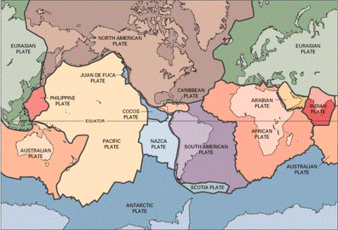
Distribution of the major lithospheric plates of the Earth. These plates move ponderously about the globe, powered by convection in the underlying asthenosphere. (Image: USGS)
Plate Boundaries
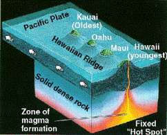
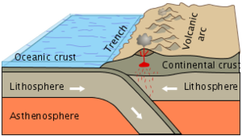
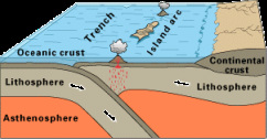
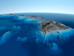
There are three types of boundaries between the tectonic plates: 1) Divergent boundaries - mid-ocean spreading ridges that generate new oceanic crust. Because the plates are pulling apart, these are “extensional” boundaries. 2) Convergent boundaries - where one lithospheric plate dives under another in a process called subduction. These are “compressional” boundaries. 3) Transform boundaries - where plates slide horizontally past each other along giant faults. California’s San Andreas fault is the best-known transform plate boundary. Mid-Ocean Spreading Ridges Most plates diverge (move away from each other) at mid-ocean spreading ridges. The mid-ocean ridges are undersea mountains more than 12,000 feet high and 1,200 miles wide. Molten rock moving upward by convection reaches the surface along these ridges and releases much of the Earth’s internal heat. Near the surface, the oceanic lithosphere is mostly basalt, a black, fine-grained volcanic rock. As molten rock rises to the surface, the entire oceanic lithosphere moves away from the spreading centre. In this way, new ocean floor constantly forms and slides away from either side of the ridge as solid plates of the lithosphere. This process is responsible for the phenomenon known as “seafloor spreading.” Hot Spots When convection rises as a single plume rather than along a linear spreading ridge, the result is a “hot spot.” On the surface, hot spots erupt as volcanoes of dark, basaltic-type rocks. The source of the molten rock is probably at the core-mantle boundary. Hot spot volcanoes often form long chains that result from the relative motion of the lithosphere plate over the hot-spot source The Hawaiian Islands* are our best-known modern examples of hot spots derived from mantle plumes. Another well-known example is the hot spot beneath Yellowstone National Park today. As we’ll see, hot spots have played a major role in creating some of Washington’s volcanic regions. *Update: See scientists' latest views on the creation of the Hawaiian Islands at the end of this article. Subduction Zones: The Ultimate Fate of Oceanic Crust A subduction zone is a boundary where two tectonic plates collide and, because of differences in density, one dives beneath the other. Plates carrying oceanic rocks move across the face of the planet until they run into an obstruction, typically a continent. Continents are made of lighter rocks such as granite. When the two plates collide, the heavier oceanic rocks sink downward (are subducted) underneath the lighter continent. Where the ocean plate dives underneath the continent, a deep trench forms adjacent to the edge of the continent. Trenches within subduction zones are the deepest depressions of the Earth. Continental Arcs When the floor of an oceanic plate subducts beneath a continent, high pressures, high temperatures and high water concentrations combine to melt some of the lighter minerals in the descending plate. These molten rocks form bulbous bodies (like in a lava lamp) of silica-rich magma called “plutons,” named after Pluto, the Greek god of the underworld. Many plutons never reach the surface. Rather, they cool and crystallize into bodies of granite deep beneath the Earth’s surface. Some plutons, however, make their way to the surface and erupt as a chain of volcanoes rising along the edge of the continent. Geologists call the arc-shaped belt of plutons and volcanoes a “continental arc.” The modern Cascade volcanoes are a classic modern example of a continental arc. Island Arcs: Volcanoes from the Sea When two plates carrying oceanic crust collide, the winner is usually the younger of the two because plates grow colder and denser with age. The older, denser plate subducts beneath the younger plate and begins melting at depth. Molten rock from this subduction rises to the surface to erupt as an arc-shaped chain of volcanic islands. These chains are “island arcs”. The volcanic islands of Japan are a modern example of an active island arc system. As we’ll see, ancient island arcs played a major role in Washington’s geologic history The Plate Tectonic System The illustration below shows how all three types of plate boundaries (convergent, divergent and transform) operate as part of a vast global system. New oceanic lithosphere forms at divergent plate boundaries such as mid-ocean spreading centers and continental rift zones. The lithosphere and oceanic crust descend along subduction zones located either at continental boundaries or in convergence with other oceanic crust. In both cases, a volcanic arc at the surface reflects the partial melting of the subducting slab at depth and the upward movement of magma bodies (plutons). The creation and destruction of oceanic lithosphere occur at about the same rate on a global scale. Types of plate boundaries
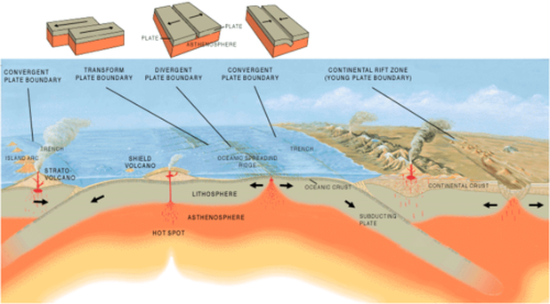
Artist's cross-section illustrating the large-scale interaction of the main types of plate boundaries. (Image: USGS)
The Supercontinent Cycle
As the continents have moved through time, they have repeatedly collided to form “supercontinents.” Most of the rocks that make up continents are insulators -- they are reluctant to transfer thermal energy. Eventually, heat builds up beneath the continent. The continental crust swells, stretches, and finally ruptures. New ocean floor begins to build within the rupture zones. Fragments of the supercontinent spread as the ocean plate grows along a new seafloor spreading center. Because the Earth is a sphere, the moving continental fragments inevitably reassemble about every 500 million years. As we will see, the creation and destruction of giant continents has played a major role in the geologic history of Washington and the Pacific Northwest. The most recent supercontinent was Pangaea. It formed about 300 million years ago when the isolated continents collided. The creation of Pangea meant that only one large continent existed on the Earth, balanced by one large ocean called Panthalassa (Greek for "all seas"). Beginning about 230 million years ago (and still going on today), the present Atlantic ocean formed and began spreading. Pangea broke apart completely, and the continental fragments are now scattering across the globe. The modern Atlantic Ocean is spreading at the expense of the Pacific. As North America moves westward, the Pacific Ocean basin is getting smaller along subduction zones (convergent plate boundaries) under North and South America, and Japan, as western North America and Asia get closer together. Sometime in the future the Pacific ocean will close completely and Asia and North America will collide to form yet another supercontinent. Before Pangaea, yet another supercontinent called Rodinia existed between 1.2 billion and 750 million years ago. It also formed from the accumulation of isolated continents, only to fragment 350 million years after its formation. There is growing evidence that even older supercontinents predated Rodinia early in Earth’s history. This supercontinent cycle – the assembly, rupture, breakup, spreading and reassembly -- has left an indelible record on the geology of the Pacific Northwest.
|
|
Scientists say source of Hawaii volcanism found
Posted on May 28, 2011 by The Extinction Protocol For years, researchers have debated whether or not the Hawaiian hot spot — the active volcanic region that created the islands — is fueled by a plume of hot magma rising straight up from the Earth’s depths. Not so, new research finds. Instead, a giant, deep thermal anomaly hundreds of miles wide located far west of Hawaii is what feeds the island’s volcanoes, scientists find. “Conventional wisdom believes that the plume may come all the way from the boundary of Earth’s core.” said researcher Qin Cao, an MIT seismologist. “Seismologists have been searching for evidence to support or invalidate this deep-rooted plume model, yet a lot of debate still exists.” To find out more about the magma feeding the Hawaiian volcanoes, researchers used seismic waves that bounced off rocks in the mantle layer to image activity beneath Hawaii, a technique adopted from oil and gas exploration. Instead of a narrow vertical plume of magma beneath the islands driving volcanic activity, scientists discovered that a thermal anomaly about 500 to 1,250 miles (800 to 2,000 kilometers) wide and about 450 miles (725 kilometers) deep and far to the west of the islands apparently triggered their volcanism. “Our result doesn’t support the picture that Hawaii is fed directly by a deep-rooted mantle plume rising from the core-mantle boundary,” Cao told OurAmazingPlanet. “Instead, it may be fueled by a secondary plume from a large pool of hot materials trapped on the top of the lower mantle.” (The mantle is the layer of high-pressure and temperature, flowing rock between the Earth’s core and crust.) “Numerous similar secondary upwellings can be generated from this hot pool, too, due to thermal instability,” Cao added. “So an interesting question to ask is, ‘Are there any other secondary-plume-generated volcanoes around this area of Pacific seafloor several hundreds of kilometers away from the big island of Hawaii that have gone unnoticed so far, or which have since been subducted (recycled back into Earth’s deep interior) deep beneath Japan and the Philippine Sea Plate farther west?’” This research suggests that any volcanism seen in the interiors of tectonic plates — instead of at their borders, as is usually the case — need not originate from plumes rising all the way from the Earth’s core, but could arise from the boundary of the upper and lower mantle. –Discovery News |
