www.spaceweather.com
|
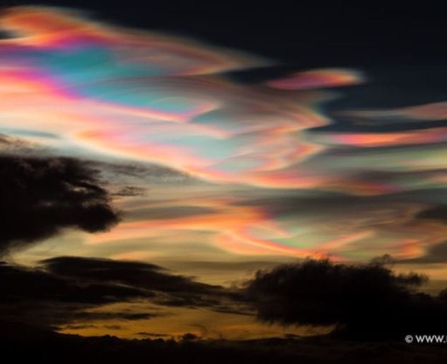
Around the North Pole, the stratosphere has suddenly become very, very cold. NASA satellites are registering temperatures less than -85 C, the threshold for formation of rare polar stratospheric clouds (PSC). In the past few days, colorful PSCs have spilled outside the Arctic Circle, spreading as far south as Scotland. High-latitude sky watchers should remain alert for these clouds as the outbreak continues.
www.spaceweather.com
0 Comments
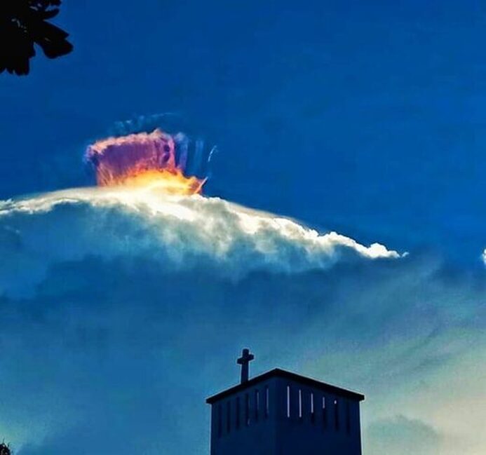
Jay Nelz, Philippine News, Thu, 15 Apr 2021 The mysterious cloud formation spotted in Oriental Mindoro garnered various speculations from the online community. The Facebook page "Youth for Mindoro" has shared the amazing photos of a strange cloud formation in Mansalay, Oriental Mindoro. The phenomenon happened last Wednesday afternoon (April 14, 2021). According to the witnesses, the mysterious light has been formed above the clouds. The weird light looks like a crown roaring above the cloudy, which garnered various reactions from the social media users. The unique cloud formation has been already spotted in different parts of the world such as Costa Rica and America. The optical phenomenon usually appears when a ray of sunshine hits the ice crystal inside the clouds. The process results to formation of various colors within the clouds, which is called rainbow-effect. The refraction is also known as "cloud iridescence".
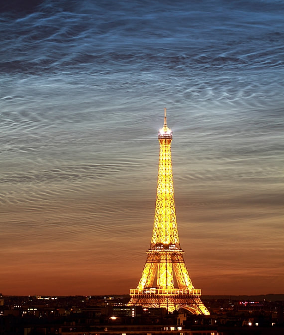
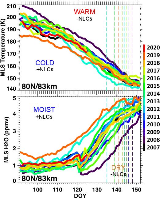
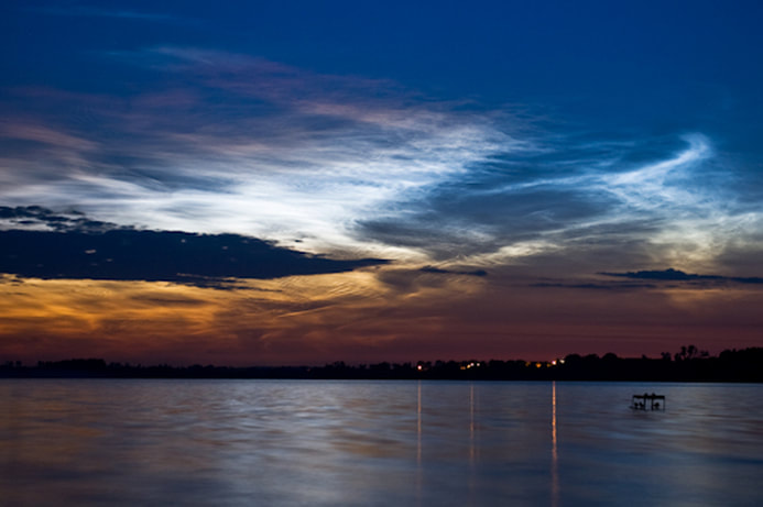
Here is the full post. www.spaceweather.com Last summer, sky watchers in the northern hemisphere witnessed the finest outbreak of noctilucent clouds (NLCs) ever. Normally confined to polar regions, the rippling blue clouds spread as far south as Las Vegas, Nevada, and Los Angeles, California, smashing old records for low-latitude visibility. One of the brightest displays occurred over Paris, France: "On June 21, 2019, the day of the summer solstice, these rare noctilucent clouds were visible over Paris," says photographer Kulik Bertrand. "It was amazing!" NLCs are Earth's highest clouds. Seeded by meteoroids, they float at the edge of space more than 80 km above the ground. The clouds form when summertime wisps of water vapor rise up to the mesosphere, allowing water to crystallize around specks of meteor smoke. In the northern hemisphere, noctilucent cloud season typically ranges from mid-May through mid-August. Given that 2019 was such a record-breaker, researchers are naturally wondering what will happen in 2020. Could NLCs spread even farther south? To try to answer that question, Lynn Harvey of the University of Colorado's Laboratory for Atmospheric and Space Physics has taken a look at data from NASA's Microwave Limb Sounder (MLS). She prepared the following plots, which show moisture and temperature in the mesosphere for the past 14 years--including 2020: Moisture and temperature are key ingredients of NLCs. The clouds flourish when the mesosphere is extra cold and wet. Harvey's plots show 2020 (red) splitting right down the middle of other recent years--not too cold and not too wet.
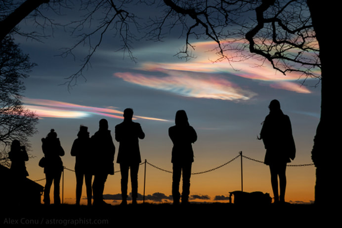
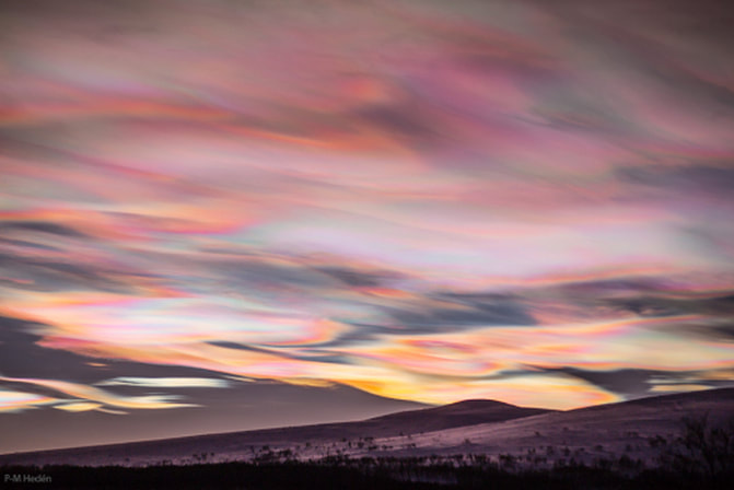
"So far, 2020 is shaping up to be fairly average," says Harvey. In other words, 2020 does not look a repeat of 2019. This summer's clouds might be confined to higher latitudes again. No one will know for sure, however, until NLC season actually begins. Daily images of NLCs from NASA's AIM spacecraft are posted right here on Spaceweather.com. "Based on the MLS data, I would guess that the first NLCs will be spotted in two weeks or so," she says. Stay tuned to see if the forecast is correct! www.spaceweather.com The finest outbreak of polar stratospheric clouds (PSCs) in decades is still going strong. "We witnessed a wonderful display this evening (Jan. 8th)," reports Alex Conu, who photographed the clouds drawing a crowd in Oslo, Norway: "The cloud's bright pastel colors looked fabulous alongside Venus in the evening sky," he says. Polar stratospheric clouds are rare. Normally, the stratosphere has no clouds at all. A few times each winter, however, icy clouds form when the temperature in the stratosphere drops below -85C. Such staggeringly-low temperatures are required to help sparse water molecules stick together. This winter, the clouds have been appearing daily since late December, a sign of unusually cold conditions in the stratosphere. Stratospheric clouds are widely regarded as the most beautiful clouds on Earth. Because of their intense colors (caused by high-altitude sunlight hitting tiny ice crystals), novice sky watchers sometimes mistake the clouds for auroras. This picture from P-M Hedén of Tänndalen, Sweden, shows why: "On Jan. 4th, the colors got so strong that the snow turned red," marvels Hedén. "I have been seeing these crazy displays at both sunrise and sunset from my cabin in the Swedish mountains."
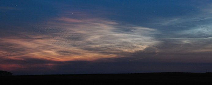
Stay tuned for updates as the outbreak continues. www.spaceweather.com Noctilucent clouds are supposed to be electric blue, yet during the extreme NLC outbreak of June 1st, some observers in Europe saw a different color: red. "It happened around midnight," reports Marek Nikodem of Szubin, Poland. "The top of the clouds developed a reddish-purple canopy." It didn't last long, but he was able to photograph the amber crown before it faded away: Above: Red and blue noctilucent clouds over Szubin, Poland. Credit: Marek Nikodem "What creates this color?" The answer is ozone--or rather, lack thereof. Research in the 1970s revealed that much of the sunlight hitting noctilucent clouds first passes through Earth's ozone layer. Ozone absorbs red light, while allowing blue to pass--hence the usual color of the clouds. When the sun is hanging very low, however, reddened sunlight refracted through the dense troposphere can paint the tops of NLCs red, overwhelming the usual "ozone blue." Above: Mostly red noctilucent clouds over Piwnice, Poland. Credit: Piotr Majewski PS: Ozone isn't the only reason noctilucent clouds are blue. The clouds consist of tiny ice crystals about the size of particles in cigarette smoke. Cigarette smoke looks blue, too, and for the same reason. Tiny particles scatter blue light better than other colors.
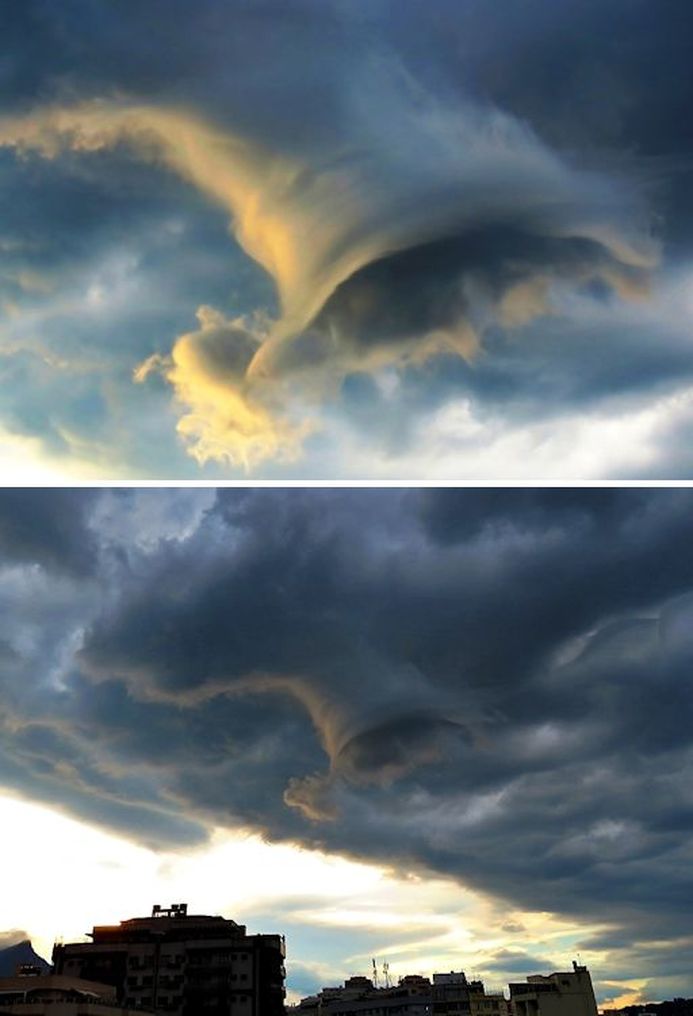
www.spaceweather.com Note to photographers: When you see a funnel cloud reaching down out of a stormy sky, the correct response is usually Run! Brazilian photographer Helio C. Vital made a different choice. Click! He snapped this picture on Feb. 7th from Rio de Janeiro: "The cloud appeared about a half hour before sunset," says Vital. "It was part of a thunderstorm cell that was approaching, announcing the arrival of a new weather system that would bring rain to the city several hours later."
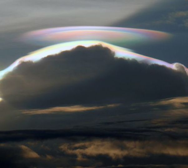
Meteorologists call this type of cloud a "tuba" -- a swirling mass of moist air that can hang down from an active thunderstorm. A tuba that touches the ground gets a new name: tornado. "Fortunately, in spite of its threatening appearance, this tuba did not reach the ground and no damage was reported," says Vital. Click! was the correct choice after all. www.spaceweather.com On Jan. 6th, Peter Lowenstein observed a rainbow-colored saucer over Mutare, Zimbabwe--but it wasn't a UFO. "This is a classic example of a pileus cloud," he says. Pileus clouds form on sunny afternoons when the heat of the summer sun causes cumulus clouds to boil upwards. Roiling toward the sky, cumulus clouds push layers of moist air above them where they cool and condense to form droplet-rich cloud caps or 'pileus' (Latin for cap).
Sometimes, as in Mutare on Jan. 6th, pileus clouds form very quickly. In such cases their water droplets tend to be all the same size--the perfect condition for iridescent colors. Lowenstein took four pictures over a period of just three minutes. "They show the cloud appearing, then changing shape and color," he says. "One minute later it had disappeared behind the summit of the growing cumulonimbus cloud." www.spaceweather.com Earth's stratosphere is normally free of clouds. Not this weekend, though. Observers around the Arctic Circle are reporting an outbreak of brilliantly-colored icy clouds in the typically dry and transparent layer of our planet's atmosphere. Eric Fokke photographed the display on New Years Eve from the Lofoten Islands of Norway: These icy clouds are a sign of very cold temperatures. For ice crystals to form in the arid stratosphere, temperatures must drop to around -85º C. High-altitude sunlight shining through tiny ice particles ~10µm across produce the characteristic bright iridescent colors.Once thought to be mere curiosities, some polar stratospheric clouds (PSCs) are now known to be associated with the destruction of ozone. Indeed, an ozone hole formed over the UK in Feb. 2016 following an outbreak of ozone-destroying Type 1 PSCs.
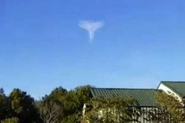
These clouds really are as amazing as they look in Fokke's photo. They have much more vivid colors than ordinary iridescent clouds, which form closer to Earth in the troposphere. Once seen, a stratospheric cloud is never forgotten. www.spaceweather.com Rosie Vare : AOL Travel UK : 20 Oct 2016 © Cory Hearnon/Facebook This unusual shaped cloud has been spotted in the sky over South Carolina. Cory Hearn captured on camera the rare weather phenomenon, which appears in the shape of an angel with its wings spread wide. Speaking on the footage, Cory says: "Check that out. Is that not an angel or what? Nobody would believe me if I didn't do this live, but I want you to look at this cloud in the sky. I don't know that I've ever seen with my own two eyes this type of cloud. Isn't it amazing? I'm seeing an angel, I don't know if anybody sees anything different." He later told People that it was the most amazing thing he'd ever seen in his life. "This couldn't have come at a better time and other people seem to agree." Published on Oct 19, 2016
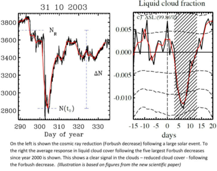
It’s not often an angel is spotted in the sky, but a curious onlooker managed to capture what turned out to be a cloud shape of a guardian on Facebook Live. Cory Hearon filmed the cloud in Camden, South Carolina, and the live stream has now been viewed more than 7 million times. SC Man's Video of 'Angel'-Like Cloud Goes Viral South Carolina Man Captures ‘Angel’ Cloud on Video: ‘It’s a Sign Everything Is Going to Be Okay’ Last week, the Camden, South Carolina, father of three was in his car when he looked to his left and saw an angel-like cloud formation that left him awestruck. “It was the most amazing thing I’ve ever seen in my life,” Hearon, 37, tells PEOPLE. “I was in shock for the first two minutes, and I thought I better get a video of this so there won’t be any question or doubt about what I saw,” he says. Hearon, who says he watched the cloud for 45 minutes before it started to dissipate, posted a Facebook Live video that has received millions of views. “Look at this cloud in the sky. Is that not an angel or what?” he says in the video. “This is blowing my mind.” The connection between cosmic rays and clouds has long been controversial. Some researchers hold that cosmic rays hitting Earth's atmosphere create aerosols which, in turn, seed clouds. This could make cosmic rays an important player in weather and climate. Other researchers, however, are less convinced. Although some laboratory experiments support the idea that cosmic rays help seed clouds, skeptics say the effect is too small to substantially affect the cloudiness of our planet or to avert the course of climate change. A new study just published in the Aug. 19th issue of Journal of Geophysical Research: Space Physics comes down in favor of cosmic rays. A team of scientists from the Technical University of Denmark (DTU) and the Hebrew University of Jerusalem has linked sudden decreases in cosmic rays (called "Forbush Decreases") to changes in Earth's cloud cover. Forbush Decreases occur when solar storms called "coronal mass ejections (CMEs)" sweep past Earth. Magnetic fields in CMEs deflect cosmic rays and, essentially, sweep some of the cosmic rays away from our planet. The research team led by Jacob Svensmark of DTU identified the strongest 26 Forbush Decreases between 1987 and 2007, and looked at ground-based+satellite records of cloud cover to see what happened. In a press release, their conclusions were summarized as follows: "[Strong Forbush Decreases] cause a reduction in cloud fraction of about 2 percent corresponding to roughly a billion tonnes of liquid water disappearing from the atmosphere."
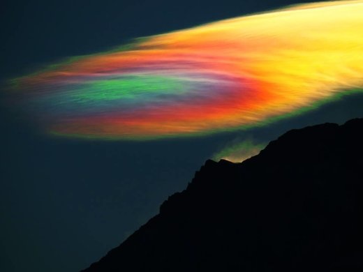
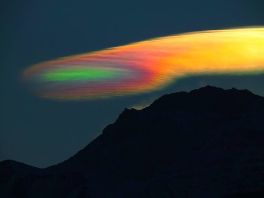
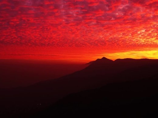
If true, that's amazing. It would also underscore the importance of measuring cosmic rays in the atmosphere. Recent balloon flights by Spaceweather.com and Earth to Sky Calculus show that cosmic rays are intensifying. Cloudy days, anyone? www.spaceweather.com Strange Sounds : 21 Jul 2016 This eerie iridescent cloud appeared over Santiago de Chile at sunset on July 15, 2016. This is one of the most unbelievable rainbow clouds I have ever seen in my life! Cloud iridescence is a fairly uncommon phenomenon, when colors appear in a cloud, most often altocumulus, cirrocumulus, lenticular clouds and cirrus clouds. © Roberto Antezana Iridescent clouds are a diffraction phenomenon caused by small water droplets or small ice crystals individually scattering light. The colors are usually pastel, but, as in these pictures, they can be very vivid. Newly forming clouds produce the brightest and most colorful iridescence. © Roberto Antezana Iridescence is generally produced near where the sun appears in the sky, with the sun's glare masking it, so it is more easily seen by hiding the sun behind a tree or building. In our case, it was hidden by the Andes. Other aids are dark glasses, or observing the sky reflected in a convex mirror or in a pool of water. Or one can simply block the sun (but not the cloud) with the palm of one's hand. A few days before, this blood red sunset sky engulfed the smoggy sky of Santiago de Chile. © Roberto Antezana These pictures are almost scary! as if we were playing with our atmosphere, with the clouds in the sky.
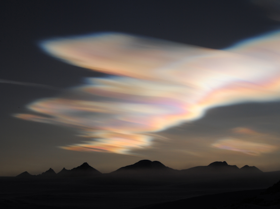
The stratosphere is a relatively clear layer of Earth's atmosphere, almost always cloud-free. Almost always. On Monday, researchers at Argentina's San Martín Base spotted a bank of fantastically colored clouds floating in the stratosphere above the Antarctic Peninsula: "There were the biggest stratospheric clouds we've seen so far this year," says photographer "Marcelo," who is working at the Base this winter. "It was a colorful spectacle to begin the day."
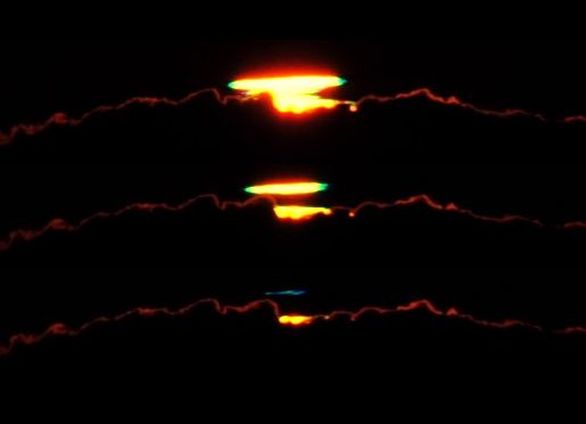
These are called "Polar Stratospheric Clouds" (PSCs). They form in the lower stratosphere when temperatures drop to around minus 85º C. This explains why they are rare; even at the poles, such low temperatures are hard to achieve. High-altitude sunlight shining through tiny (~10µm) ice particles in PSCs produce bright iridescent colors by diffraction and interference. Once thought to be mere curiosities, some PSCs are now known to be associated with the destruction of ozone. www.spaceweather.com Seaside photographers have a special fondness for the sunset. On rare occasions they can catch the elusive green flash--a split-second pulse of verdant light that signals the disappearance of the sun beneath the ocean waves. On April 7th, astronomy professor Jimmy Westlake photographed a green flash as he stood atop Hawaii's Mauna Kea volcano. The flash he saw, however, did not come from the ocean waves. It happened in the clouds: "The SKY Club from Colorado Mountain College got an emerald surprise," he says. "Several students visually witnessed the green flash while I was photographing it."
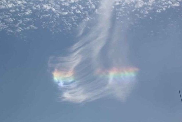
"This appears to be a cloud-top flash," says atmospheric optics expert Les Cowley. "They are not fully understood but might be produced by an inversion layer overlaying the clouds. We need more observations and associated weather data to understand them better." Basically, a temperature inversion bends the sun's rays to form a mirage that vertically magnifies the tiny color separation which is always present at the edge of the setting sun. Indeed,in Westlake's flash, we see not only green, but also yellow, red, and even a wisp of blue. "The intensity of the blue-green flash caught everyone by surprise!" says Westlake. www.spaceweather.com Strange Sounds : 26 Mar 2016 © Alfonso Topete Ramos This mysterious iridescent cloud fell from the sky just after the Stations of the Cross parade in Yago, Nayarit, Mexico.
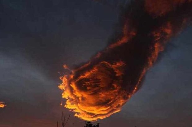
Patrick Knox : Daily Star (UK) : 27 Jan 2016 © MERCURY A cloud that took the form of a 'hand of God' holding a fireball dominated the skyline above the north coast of the Portuguese island of Madeira. And weather blogger Rogerio Pacheco, 32, could not believe his luck when he looked up at the clouds while commuters made their way to work in the morning rush hour.
The awe-inspiring snaps have since been shared online after Rogerio opted to post them on his blog. Amazed onlookers have compared the bright orange cloud to everything from a flaming fist of fury to the iconic comet featured in the classic video game Final Fantasy VII. Rogerio said: "As soon as I saw the sky, I was immediately intrigued and I just had to grab my camera to take a photo. For me, the cloud looks like an outstretched hand with a fireball. I was not the only one who seemed to notice it and I could see other people also looking up at the sky. A lot of people seemed pleasantly surprised when they looked up at the sky and saw the cloud." |
QUICK INFO
Author:
_Messenger Spirit This section is for interesting items which are brought to my attention but which do not merit a separate article.
I welcome your comments, questions or suggestions on any topics you wish to contribute to this section. Please submit these on the Contact and Feedback Form PLEASE DO NOT SUBMIT COMMENTS ON THE FORM WHICH APPEARS UNDER ITEMS ON 'QUICK INFO'; THIS SYSTEM IS NOT WORKING. Categories
All
Archives
July 2024
|
 RSS Feed