June 15, 2013 FALMOUTH — It was late afternoon Thursday and Jim Limberakis, 60, was working at his Falmouth Harbor waterfront restaurant, The Clam Shack. Suddenly the harbor water started doing something he'd never seen in his 50 years at that location.
"We noticed this huge surge of water going out of the harbor almost like a riptide with waves building up at the entrance," Limberakis recalled. "Then it suddenly surged back into the harbor." That back and forth surge of water continued for about an hour, Limberakis said, and then it was gone.
"It was the strangest thing I'd ever seen," he said. "I've been here since I was a kid, and I've never seen anything like it."
It was a tsunami, said U.S. Geological Survey oceanographer Jeff List, whose office is in Woods Hole. It just wasn't the earthquake- or landslide-generated surges people know and fear. This was a fairly rare meteotsunami, which originates with changes in atmospheric pressure.
Think of the intense low pressure in the center of a hurricane, which has a barometric pressure significantly lower than the air around it. The decreased downward force on the water allows water at the center of the storm to rise into a mound that is higher than the level of the surrounding ocean.
When a large front moves out over the sea, like one that moved offshore Thursday, there is a similar difference between the air pressure of the front and the air over the ocean. That drop in air pressure mounds up the water beneath it and, if the speed of the incoming weather system matches that of the deep water waves below, it can generate a tsunami, just like one generated by an earthquake or a landslide.
"Once it's released it's a tsunami," List said. "When it encounters a V-shaped bay on the coast, it can get amplified."
The effect depends on coastal topography, List said. "Someone could have been standing at Falmouth Heights and not even noticed a 2-foot rise and fall."
But Falmouth Harbor does have a long V shape and the effects of the surge were magnified.
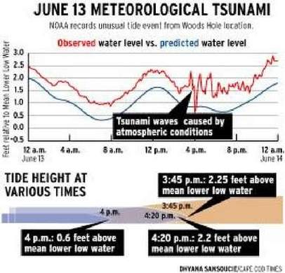
List believes that the tsunami, which seems to have extended from Montauk, Long Island, up to Chatham, was probably spawned somewhere between New Jersey and New York. It doesn't appear to have caused any damage. The biggest differential in water height was a little under 2 feet above and below the tide height, according to tidal records kept by the National Oceanic and Atmospheric Administration in Woods Hole.
A review of NOAA tide data from Thursday clearly shows the repetitive oscillation of a falling tide erupting in peaks and valleys that resemble a seismic readout of an earthquake, as the initial wave bounced off the Cape shoreline, then off other objects in Vineyard Sound and back again.
"It's like throwing a stone into a pool," List said. "They do have the potential to be dangerous."
A meteotsunami hit Boothbay Harbor and the central coast of Maine in 2008 with a surge estimated at between 4 and 12 feet high.
The Great Lakes are actually considered a meteotsunami hot spot.
On Thursday, Bob Boden was coming into Falmouth Harbor at around 4 p.m. from a trip as captain of the ferry Quickwater. "The current in front of our dock usually runs at about a half-knot at most. This was running at 5, 6, 7 knots," he said. The water level in the harbor dropped by more than a foot in 10 minutes, Boden said.
Boden and Limberakis had seen the videos of the water flowing out to sea just before the big tsunamis that hit Indian Ocean beaches in 2004. "Really, it was kind of spooky. What's next, we asked, a tidal wave?" Limberakis said.
METEOTSUNAMIS: For more on meteotsunamis go to: http://meteotsunami.weebly.com/history.html

 RSS Feed